Introduction To
Identification of Ritchie County, WV, Prehistoric Projectile Points
and Artifacts
All identifications which appear on the
following pages were made from photographs made by the author either
in the field (at the home of the artifact collector) or at the
Ritchie County Public Library. Identification from photographs is
possible because archeologists have determined the ages of artifacts
of the several types named in this pamphlet by scientific techniques,
including stratification and carbon-14 dating. It is inferred that
artifacts sharing the same design characteristics will be of the same
approximate age, having been made by related culture groups during
the same cultural period.
It should be noted that projectile
points of the same design are often called by different names in
different regions of the United States. Local researchers often
operate in relative isolation from others doing the same work, and
thus different names for the same artifact type arise. With a few
exceptions, projectile points in this pamphlet are given names
established for West Virginia points. It should be understood,
though, that some of the projectile point types shown here may be
found over most of the eastern U.S.
It was noted that several of the
projectile point types included in this pamphlet have counterparts in
other regions, especially in Illinois, Michigan and the Great Lakes
Region, New York, Pennsylvania, Ohio, Kentucky, Tennessee, Alabama,
and Texas.
Many different types of flint and other
materials were used in the production of projectile points found in
Ritchie County. Some projectile points were undoubtedly made of flint
from Flint Ridge, Ohio, and others appear to have been made from
Black Kanawha flint, from the Kanawha Valley in WV. But it is
important for the scientific community to recognize that the majority
of flint chips found at the several prehistoric sites in the county
came from local sources, i.e., the Hughes River Flint, and another
outcrop on Goose Creek, near Combs Run. At least half of the
projectile points illustrated in this pamphlet are of this easily
identifiable local flint. Yet nowhere in the archaeological
literature of this state is the Hughes River flint mentioned as a
source of flint for tools of primitive man in West Virginia. This
seems odd, especially since a 1956 publication of the West Virginia
Geological Survey mentioned the Hughes River flint as the only
notable deposit of flint in the Ohio River Valley in West Virginia
(Cross & Schemel, et, al, Geological and Economic Resources of
the Ohio Valley in West Virginia.
The author believes that the sheer
number of artifacts illustrated here should cause Ritchie County,
long ignored by archeologists, to take its place among other regions
of this state which have been noted in state publications as sites of
primitive ancestors of the American Indians. The Kanawha Valley in
the southern portion of the State, the Monongahela Valley to the
east, and the Northern Panhandle region have all been noted as
primary sites of occupation by primitive man. Recent investigation
has begun to identify the Parkersburg area, specifically
Blennerhasset Island, as a primary archaeological site in West
Virginia. But it is important to consider that these areas are
economically more developed than Ritchie County, and thus
archaeological work by professionals is more readily solicited and financed. Such
research does not establish that these sites were occupied on a
larger scale, or for longer periods of time than Ritchie County, only
that professional archaeological investigations have been possible
there due to favorable economic conditions. If this
many artifacts (those illustrated here) can be found in Ritchie
County on the surface, then how much more could professional
archeologists discover by planned and systematic excavations?
It has not been possible to identify
all projectile points illustrated here. Of the more than 550 points
and stone tools illustrated, 220 have been tentatively identified and
fixed within a certain time period. Many of these identifications
were made at the author's request by the Archeology Section Team of
the West Virginia Geological and Economic Survey under the
supervision of Dr. Thomas Hemmings. Those identified by the
Archeology Section are so indicated.
Many of the projectile points not
identified show distinct characteristics like established forms, but
not enough 1ike'established forms to place them in any certain
category. Other types are illustrated which are totally unlike other
projectile points known in this or other regions. Such unique points
reflect the possible isolation of some prehistoric Indian groups in
Ritchie County, perhaps purposely out Of touch with neighboring
regions, developing projectile point types as well as other cultural
manifestations in relative freedom from outside influence.
Ritchie County can be considered an
attractive "micro-environment" for primitive man--an area
within ten miles of the Ohio River at its northwestern boundary. This
nearness to the Ohio explains the early interest of Archaic Cultures
in the region of Ritchie County. The Ohio River is a well established
migration and cultural diffusion route for primitive man. And Ritchie
County is connected to the Ohio River by the Little Kanawha and
Hughes Rivers. The Little Kanawha was once marked by a prehistoric
travel route, a branch of the Seneca or Shawnee Trail--a major
North-South trail for Indians in prehistoric as well as historic
times. Another major travel route for both historic and prehistoric
Indians, the Scioto-Monongahela Trail, had a branch which bisected
Ritchie County, following the course of the present B & 0
Railroad. These routes (one east-west, the other north-south)
establish Ritchie County as a well traveled area by both prehistoric
and historic Indians. Ritchie County was off the beaten path for
Paleo-Indians and the first Archaic Indians to follow them to the
Ohio Valley, but the assemblage of Early Archaic artifacts in this
pamphlet indicates that it was not long after the arrival of man in
the Ohio Valley before he found his way to Ritchie County. The total
assemblage of artifacts from prehistoric Indian cultures indicates
that the ancestors of the Indians were in Ritchie for more than
10,000 years, occupying hilltop and riverine sites along major
waterways--the same sites first selected by the county's first White
settlers.
All attempts such as this one to
identify artifacts which have not been found associated with an
undisturbed site are hampered by the lack of pure scientific
investigation of the relationship of the artifact to the site.
Specifically, artifacts found on the surface, such as those shown
here, cannot be dated according to their association with organic or
geologic matter for which a precise age can be determined. Thus,
although precise dates cannot be assigned for the artifacts
illustrated here, a comparison of these artifacts with others of the
same type which have been precisely dated will indicate an
approximate age.
As will be noted in plates identified
as from the author's collection, the author has investigated several
sites where artifacts were found by collectors, and has found a
number of artifacts himself at those sites. Such finds, together with
the known character of collectors mentioned in this pamphlet, have
influenced the author to rely upon the truthfulness of collectors in
assuming that artifacts were indeed found at the locations where they
have stated they were found. This statement is made to discourage the
assertion by skeptics that "those artifacts could have come from
anywhere," a criticism which is anticipated. All such skeptics
are encouraged to come to Ritchie County and "see for yourself.
William A. Cox, Jr.
Harrisville, WV,
1979
Recognized Archeological Sites in Ritchie
by William A. Cox, Jr., Staff Historian
Ritchie County Public Library -- 1979-1980
[From The Ritchie Gazette, c.1979]
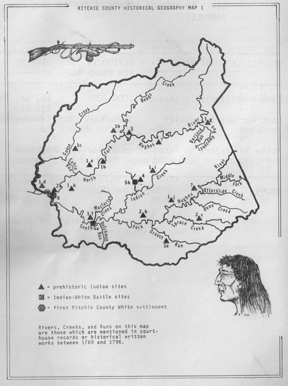
Seven prehistoric sites have been identified and recorded within Ritchie County by the Archeology Section of the West Virginia Geological Survey, in Morgantown. Yet these recorded sites reflect only a fraction of the legacy left here by primitive man. Artifact collections have been turned by the plow in every corner of Ritchie County, and dates ranging from 10,000 to 300 years ago have been assigned to them by the Archeology Section team.
It is a policy of the Archeology Section not to make public the exact locations of established archeological sites until they have been excavated. Such a policy aims at protecting the sites from possible vandalism by private persons who may want to add to their artifact collections. Since none of the sites in Ritchie County have been excavated, their precise locations cannot be given here, but they will be located generally.
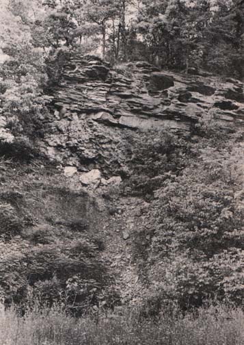 |
Old quarry along the Hughes River where Indians got flint for
spear and arrow points and other uses--photo by the author |
The information derived from undisturbed sites is invaluable to archeologists as they search for an understanding of primitive man in West Virginia, yet public curiosity does not necessarily await the progress of science, especially when the unintending plow so often turns up boxfulls of ancient relics in Ritchie County. I have witnessed this myself. On the invitation of a local farm owner to search a freshly plowed field at the junction of the Cairo-Cisco Road and Route 47, my son, David, and I found three projectile points and a stone scraper within ten minutes. So there need be no intention to disturb an ancient Indian site in Ritchie County--we simply have work to do, and fields to plow. And in response to the violent gesture of the plow, the earth yields up its aged treasures willingly, as if to remind the plowman that she welcomed the Indian to this very spot many thousands of years before, that she has kept and preserved his works.
"Site 46-rt-1" in Ritchie County identifies the only notable deposit of flint, or chert, in the entire Ohio Valley region. This flint outcrop, commonly called the Hughes River Flint, is "twelve to fifteen feet thick, where best developed. . . The color varies from light, almost milky white, to buff, to grayish black." This flint quarry alone establishes Ritchie County as a probable location of heightened activity for primitive man.
The Indians traveled great distances to find usable flint for their stone projectile points and tools. No doubt the Indians who travelled the northwestern area of West Virginia, southeastern Ohio, and southwestern Pennsylvania were familiar with this deposit. Many of the arrowpoints and other flint tools found in this large area will probably be traced to the Hughes River flint.
Site 46-rt-2 is an Indian mound near Cisco. This mound was constructed by the Adena or Hopewell cultures, between 3000 and 1500 years ago. The mound was almost totally destroyed in the late 1920's, and the artifacts were removed together with the skeleton of an Indian priest which had rested there for at least 1500 years. The original mound was about fifteen feet high. Today, nothing remains of the structure above ground level, but the Archeology Section team believes that excavations of the site may uncover sub-surface tombs, and they have recorded that private collections of artifacts from this mound are located in Mace and Elizabeth, in Wirt County. Among the known artifacts in these collectinos are a four-inch slate pendant, and a stemmed arrowpoint of Adena and Hopewell culture origin.
Site 46-rt-3, the Ayers' site in Murphy District of Ritchie County, not far from Smithville, is another Indian mound. The Archeology Section team estimates that the mound is sxty feet in diameter. This mound is capped with rocks.
Site 46-rt-4 is located on a meander of Spruce Creek, near Hazelgreen. Found at the site were several projectile points, a bone awl, and a grit-tempered fragment of pottery. The site is a probable location of a prehistoric Indian campsite.
Sites 45-rt-5, 46-rt-6, and 46-rt-7 are also identified as probable prehistoric Indian campsites. These sites are located near the South Fork of Hughes River on Little Bear Run, on Indan Run, and near Harrisville.
The photo, from an article by the author, appeared in Wonderful West Virginia magazine in September, 1978.
NUMBER
AND DISTRIBUTION OF ARTIFACTS ILLUSTRATED IN
EACH CULTURE PERIOD
Paleo-Indian
Period (14,000 to 11,000 years ago)
Late
Paleo-Indian, 1
PALEO-INDIAN
PERIOD TOTAL, 1
Archaic
Period (11,000 to 4000 years ago)
Early
Archaic, 50
Middle
to Late Archaic, 36
Late
Archaic, 26
ARCHAIC
PERIOD TOTAL, 112
Early
Archaic to Early Woodland, 12
Woodland
Period (4000 to 1000 years ago)
Early
Woodland, 26
Middle
Woodland, 44
WOODLAND
PERIOD TOTAL, 70
Late
Prehistoric Period (1000 to 300 years ago)
LATE
PREHISTORIC PERIOD TOTAL, 25
TOTAL
IDENTIFIED FOR ALL PERIODS, 220
TOTAL
ARITFACTS ILLUSTRATED, 500+
TOTAL
ARTIFACTS ILLUSTRATED INDIVIDUALLY, 176
FIGURE
1: ARCHAIC PERIOD PROJECTILE POINT TYPES ILLUSTRATED
|
PROJECTILE POINT
TYPE
|
PERIOD
IN USE
IN YEARS AGO
|
SITE
NUMBER
Historical Map 1
|
|
Unfluted Fluted (Paleo)
|
12,000-10,000
|
1h
|
|
Kessel
|
10,500-10,000
|
1j
|
|
Amos Corner Notched
|
10,000-9000
|
1e, 1h
|
|
Thebes
|
10,000-7000
|
1f, 1j
|
|
Key Notched
|
10,000-7000
|
1h
|
|
Beaver Lake
|
10,000
|
1j
|
|
Big Sandy
|
10,000-5000
|
1f
|
|
Kirk Corner Notched
|
9000-8700
|
1a, 1b, 1e, 1f,
1h, 1j
|
|
Russel Cave
|
9000-7000
|
1h
|
|
MacCorkle Stemmed
|
8850-8750
|
1e, 1j
|
|
Kirk Stemmed
|
8800
|
1b, 1h
|
|
Le Croy Bifurcated
|
8300
|
1e, 1h, 2a
|
|
Kanawha Stemmed
|
8200
|
1e, 1i , 1j
|
|
Guilford Lanceolate
|
8000-4000
|
1e, 1h, 1j
|
|
Stanley Stemmed
|
7000
|
1e, 1h
|
|
Lamoka
|
7000-6000
|
1a, 1e, 1h
|
|
Morrow Mountain I
|
7000-6000
|
1e
|
|
Morrow Mountain II
|
7000-6000
|
1a, 1e
|
|
Buzzard Roost Creek
|
7000-6000
|
1b
|
|
Brewerton Notched
|
6000-4000
|
1a, 1b, 1e, 1h,
1j, 2a
|
|
McWhinney Stemmed
|
5000-4000
|
1b
|
|
Mud Creek
|
5000-3000
|
1b, 1j
|
|
Buffalo Stemmed
|
4000-3000
|
1a, 1b, 1e, 1f,
1h, 1j
|
FIGURE
2: WOODLAND PERIOD PROJECTILE POINT TYPES ILLUSTRATED
|
PROJECTILE POINT
TYPE
|
PERIOD
IN USE
IN YEARS AGO
|
SITE
NUMBER
Historical Map 1
|
|
Buffalo Stemmed
|
4000-3000
|
1a, 1b, 1e, 1f,
1h, 1j, 1i
|
|
Perdiz
|
3500-3200
|
1i
|
|
Raccoon Corner
Notched & Jacks Reef
|
3500
|
1a, 1b, 1e, 1h,
1j, 2a
|
|
Table Rock
|
3500
|
1a
|
|
Cresap Stemmed
|
2600
|
1a
|
|
Adena Ovate Stemmed
|
2575
|
1b, 1e
|
|
Snyders
|
2500-1500
|
1b, 1e
|
FIGURE
3: LATE PREHISTORIC PERIOD PROJECTILE POINT TYPES ILLUSTRATED
|
PROJECTILE POINT
TYPE
|
PERIOD
IN USE
IN YEARS AGO
|
SITE
NUMBER
Historical Map 1
|
|
Late Prehistoric
Triangular
|
1000-300
|
1b, 1e, 1h, 1j,
2a
|
|
Fort Ancient
Triangular
|
1000-300
|
1a, 1e, 1j
|
|
Randolph
|
300-200
|
1a
|
CULTURE
PERIODS REPRESENTED BY ARTIIFACTS ILLUSTRATED
I.
PALEO-INDIAN PERIOD: From about 14,000 years ago until about 11,000
years ago. Paleo-Indians hunted large game such as the mammoth and
mastodon, and other smaller game animals such as white-tail deer and
bison. They also may have had limited knowledge of plant food
sources. Paleo-Indians did not use the bow and arrow. Their
projectile points are spear points.
II.
ARCHAIC PERIOD: From about 11,000 years ago until about 4000 years
ago. Archaic Indians were plant foragers and hunters. They also ate
fish and shellfish. Archaic Indians innovated several stone tool
types, but they did not develop the use of the bow and arrow. Their
projectile points were for use with spears or darts.
III.
EARLY WOODLAND PERIOD: From about 4000 years ago until about 2000
years ago. Early Woodland Indians developed simple agriculture, made
Indian mounds, and made progress in artistic industries. They made
small village settlements along river valleys. Includes Adena and
Hopewell Cultures in West Virginia.
IV.
MIDDLE WOODLAND PERIOD: From about 2000 years ago until about 1000
years ago. Warfare arose during this period and the bow and arrow
was probably developed. Middle Woodland Indians improved agriculture
and arts and skills, and continued to make Indian mounds. Includes
Hopewell, Armstrong, Buck Garden, Monongahela, Mississippian, and
Fort Ancient Cultures in WV.
V.
LATE PREHISTORIC PERIOD: From about 1000 years ago until about 300
years ago. Includes the Mississippian and Fort Ancient Cultures in
WV. Late Prehistoric Indians left the Ohio Valley by about 1680 as
a result of European disease and inter-tribal warfare relating to
the desire of the Iroquois tribes of New York to control the fur
trade with the English in the Ohio Valley. Historic Indian tribes
returned to WV in the early 1700's. The Fort Ancient Culture in WV
may be related to the Shawnee tribe, but this has not been
established.
MAP
LOCATIONS WHERE ARTIIFACTS WERE FOUND IN RITCHIE COUNTY, WV